
Beginners Guide to the Geology of the Lake District
Talking about rocks and geology can sometimes get a bit confusing, but we’re hoping that this blog will give an accessible introduction to some of main features you’re likely to come across when you’re in the area or out on one of our Lake District walking holidays!
In very broad terms, there are three main rock types to look out for when walking in the Lakes – handily for us, they are largely grouped together and change as you go from north to south.

Grisedale Tarn from St Sunday Crag
At the top of the National Park, the Skiddaw Group (often called the Skiddaw Slates) are the oldest rock type and were laid down by sedimentary processes almost 500 million years ago. They give rise to the smooth rounded hills of the Northern Fells. We then have the Borrowdale Volcanic Group, which were created about 450 million years ago.
These volcanic rocks are more resistant to erosion and form the high craggy mountains of the central Lakes. Further south, the lower hills are made up of slates, siltstones, and sandstones from the Silurian period, about 420 million years ago. This third category is generally known as the Windermere Supergroup. These have a much less rugged profile and explains why all the Wainwright Fells (the higher hills in the Lake District) are found north of Coniston and Windermere!
Immense pressure beneath the earth (around 300 million years ago) pushed up all the rocks and created a broad dome that gives the Lake District National Park its basic profile. But it’s then the action of ice which created most of the surface features. Glaciers formed in the central part of the Lake District produced a radial drainage pattern. So, if you look at a map of the lakes, you can see what almost look like wheel spokes fanning out from the centre – these are now the major lakes of the Lake District!
We’ve included a few locations below that are great places to walk to allow you to see each of these major rock types and their differences, and give you a better understanding of the landscape formation under your feet! This is not meant to be a technical article, but hopefully useful for any walkers with an interest in landscape / geology!
Skiddaw
You guessed it – a great place to see the Skiddaw Group! These ancient rocks are ‘sedimentary’, and were largely created from material eroded from other rocks. This broken rock debris was carried in rivers, then laid down in a sea where it was compressed into solid rock. Skiddaw is the 4th highest mountain in England, and the highest made of sedimentary rocks - its wide summit plateau and undulating curved sides are all a direct result of its geology.
The Skiddaw Group rocks are generally based around Keswick, but also extend towards Loweswater in the west, and east towards the northern shores of Ullswater. On Gowbarrow Fell for example, you mainly see the volcanic rocks of the Borrowdale Volcanic Group, but some faulting around the southern and eastern side of the fell exposes the Skiddaw Group rocks.
There’s a whole variety of rocks which make up the Skiddaw Group – sandstones, siltstones and mudstones. To complicate matters, some of the rocks in the Skiddaw Group have been 'cooked’ when hot magma rose up under the rocks after their initial formation, causing them to harden and become much more resistant to weathering. This explains the craggy appearance of the fells around Cummock Water and Rannerdale Knotts, despite them technically being part of the generally more rounded Skiddaw Group.

Striding Edge and Red Tarn
Helvellyn & Grisedale
Grisedale is such an atmospheric place to walk – best described when thinking about geology as a ‘moraine strewn glacial valley’, due to the rock deposits dotted along the valley floor. We are within the Borrowdale Volcanic Group here, and there are plenty of interesting rock outcrops on show, along with gushing waterfalls and old mining remains. Keep an eye out for Eagle Crag high up on your right. Very popular with rock climbers this is made up of a rock called rhyolite (a very silica-rich volcanic rock).
At the head of Grisedale – sitting under Dollywagon Pike and Nethermost Pike – are Cock Cove, Ruthwaite Cove and Nethermost Cove. These are the eroded hollows from which glaciers grew to then join together and scour out the Grisedale valley (and there is a great view of them all from up on St Sunday Crag). High in the mountains, these ice sculpted features (corries) are often now home to the tarns – such as picturesque Grisedale Tarn at the head of Grisedale, or Red Tarn below Helvellyn - that are such a welcoming sight on a walk.
Any mention of Helvellyn must include Striding Edge. One of the most well-known features of Lakeland, Striding Edge is the ridgeline leading up to the summit of Helvellyn. It is technically a ‘glacial arete’ (as is Swirral Edge linking up Helvellyn with Catstye Cam) and is a sharp ridge created by glaciers running out of the corries on either side, cutting back the rock until only a narrow ridgeline is left. This eastern side of Helvellyn is probably home to England’s most dramatic glacial scenery.
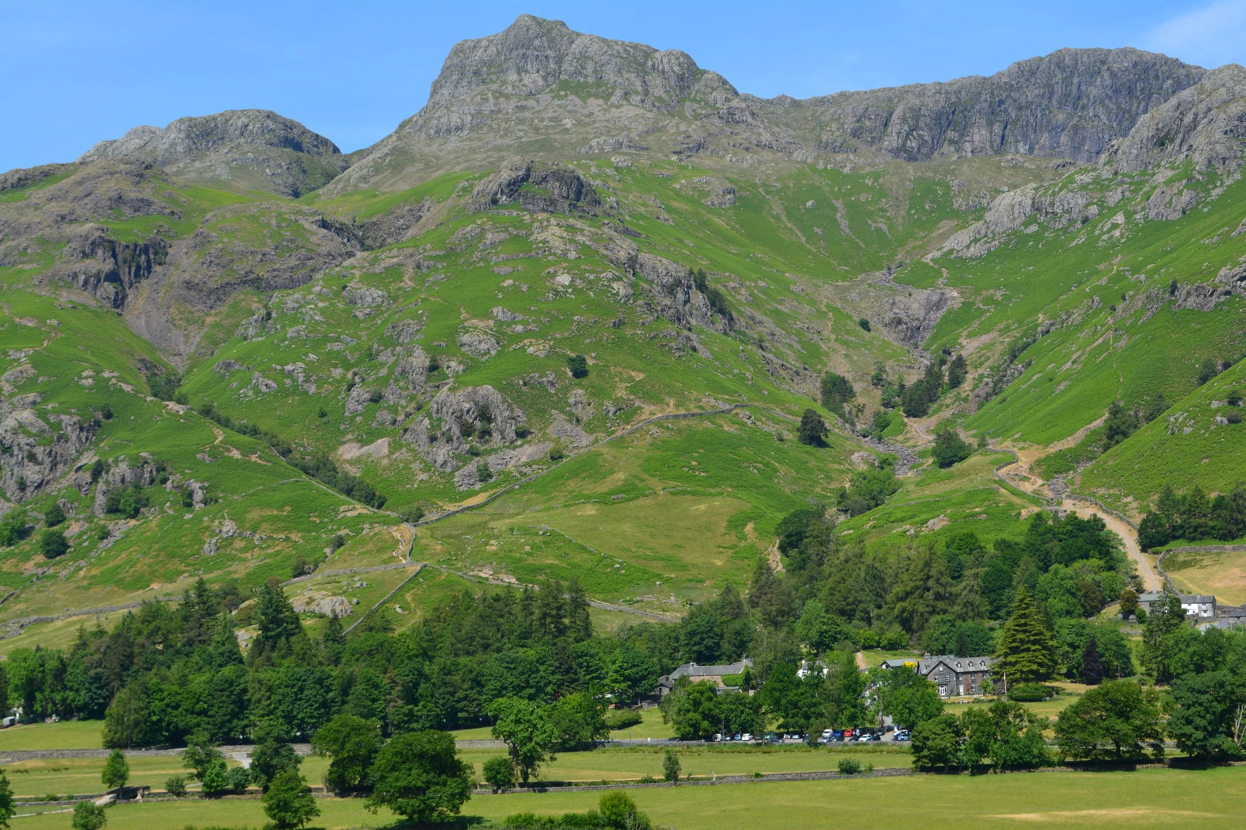
Langdale Pikes
Such an iconic image of the Lakes, the Langdale Pikes are a wonderful area to explore. Harrison Stickle rises dramatically – looking almost vertical - from the floor of the Langdale Valley with beautiful mountain scenery all around. Behind ‘the pikes’ is a large glacial plateau stretching out towards High Raise, which is right in the geographic centre of the Lake District and would have been the core of the Lakeland icefield.
This is an area of intense volcanic activity and explosions, which created the so-called Scafell caldera – a magma chamber which collapsed in on itself. At the Scafell caldera, most of the erupted material settled within its boundaries, forming thick layers of pyroclastic rocks. It is these volcanic ash layers which we now see as the crags on the summit of the Langdale Pikes.
The Langdale Pikes
Our favourite route up into the Langdale Pikes is via Stickle Ghyll and the steep walk is rewarded with glacial Stickle Tarn and the imposing backdrop of Pavey Ark. Another point of particular interest is on the approach to Pike O’Stickle. This is the site of the famous ‘Langdale Axe Factory’. First discovered in the 1930s, this rocky scree gulley was a stone age site where axe heads were mined, shaped and polished. The particular rock they were searching for was a fine-grained volcanic greenstone. Axe heads made from this specific ‘tuff’ have been discovered all over the country, suggesting that they may have had a particular importance in either trade or a ceremonial function.
Loughrigg Fell
The boundary between the volcanic rocks of the Borrowdale Volcanics and the southern sedimentary rocks is marked by a thin band of limestone that runs just south of the Old Man of Coniston, and then the Windermere Supergroup cuts a line broadly heading east from the top of Windermere.
One of the smallest Wainwright summits, Loughrigg Fell gives surprisingly vast 360 views, combining looking out over the rugged volcanic landscape to the north and east, with the much gentler rolling scenery to the south over Windermere. As with the Skiddaw Group, the landscape of the Windermere Supergroup rocks you are looking over reflects a time when the Lake District went back to being a marine environment. It is these sedimentary mudstones and sandstones that lie beneath the southern Lake District.
Loughrigg Fell itself is home to some rather complicated geology containing a whole mix of volcanic rocks. What we can see today though is a great example of something called ‘knock and lochan’ topography, which is where ice has moved across the fell and picked away at weaknesses in the rock to create small depressions and rock outcrops.
We hope you have enjoyed this introduction to some of the main geological features that you will see around the Lake District. You can see all the features mentioned here on one of our self-guided walking holidays, or as part of one of our Lake District guided walks.