
An introduction to the geology of the Yorkshire Dales
The limestone pavements, deep wide dales, heather covered moorland and many of the other well-known features of the Yorkshire Dales all owe their characteristics to the region’s geology. We have to admit that the terminology and geological processes can get a bit confusing but we’re always trying to learn more about it, and are hoping that this blog will give an accessible introduction to the main features to look out for when you’re in the area or out on one of our self-guided walking holidays!
Rock Types
Most of the rocks seen at the surface around the Dales were formed around 300 million years ago. This is known as the ‘Carboniferous period’ as it is when coal reserves were formed. Since these rocks were formed, river erosion, rainwater and ice age glaciers (and humans!) have all payed their part in shaping the landscape we know and love today.

Layers of protruding limestone visible in Wharfedale.
In the Dales, the rocks we see are ‘sedimentary rocks’ as they began life as sediments in water. They were in fact created in a shallow tropical sea near the equator and subsequent tectonic movements moved the landmass north to its current spot on the globe. Most famous of these sedimentary rocks are the limestone outcrops – formed largely from the microscopic shells and skeletons of ancient sea animals. The other main types are called ‘detrital’ rocks, which are gritstones, sandstones and shales – all formed from particles of sand, mud and other debris which has been compressed into hard rock.
Layers
Lying deep underground throughout the majority of the Dales is a foundation block of stone called the ‘Askrigg block’. This is formed of ancient sandstones, slates and gritstone, as well as some granite (which, unlike sedimentary rocks, is an ‘igneous’ rock created from once molten magma).
On top of these ‘basement’ rocks you find near-horizontal layers of ‘Great Scar Limestone’ in the south of the park and the overlying ‘Yoredale series’ in the north. The Yoredale sequence is a repeating sequence of soft shale/mudstone and harder sandstones and limestones (picture it like a big sandwich!) and there are 11 principal limestones in this series.
The ‘youngest’ rock in the National Park (so last deposited and generally highest!) is the Millstone Grit which mainly now exists at the tops of the high fells (including each of the famous Three Peaks – Whernside, Ingleborough and Pen-y-Ghent) and on the eastern side of Coverdale.
Waterfalls and fossils - The ‘Yoredale Series’ in the north

The waterfall at West Burton is a good example of waterfalls in the Yoredale series – the water flows over a layer of ‘Gayle Limestone’ and drops onto a different layer (‘Hawes Limestone’ in this case), with the intervening band of shale having been cut back by erosive power of the water.
The steady destructive forces of ice age glaciers left distinctive stepped valleys, notably in Wensleydale and Swaledale. The valley floor was also scoured by slow moving glaciers in the last ice age (about 10,000 years ago) which removed surface deposits and the valley spurs creating u-shaped valley profiles. Where the Yoredale series of rocks have been exposed, the limestone beds interspersed with shale give perfect conditions for the formation of waterfalls. The weaker shales are easily eroded and their removal by the river has caused the underlying limestone beds to undercut, leading to collapse. This results in a series of steps and waterfalls, which are particularly impressive along the length of Wensleydale and its tributary valleys. You can read more about our favourite waterfalls – and walks to do around them – in our blog here: https://www.muddybootswalkingholidays.com/blog/2020/2/21/waterfalls-of-the-yorkshire-dales.
One of the great things about sedimentary rocks is that they can be fantastic for discovering fossils – various types of marine life in this case. There are some amazing finds all over the Dales including ancient corals, large brachiopod shells, and crinoid stems. Around the waterfall at West Burton, on the slopes of Penhill, by the path out of Keld and many others are all good areas! Please do remember to leave anything where you find it though.
Cliffs and Caverns - ‘Great Scar Limestone’ in the south
Malham Cove is a great example of the erosion resistant Great Scar Limestone (which includes layers of Cove Limestone and Goredale Limestone) which marks the Middle Craven fault line. An amazing area of limestone pavement (with fantastic views!) is found at the top of the Cove.
As well as the waterfalls of Wensleydale, another great place for seeing clear signs of the underlying geology are the areas of Great Scar Limestone in Wharfedale and Malhamdale. The resistance of this hard limestone has led to the survival of very high cliffs – Malham Cove, Goredale Scar and Kilnsey Crag being the best examples. As with the Yoredale series, the Great Scar limestone is also made up of a number of layers. Subtle changes in the rock density makes certain levels more resistant to erosion than others, and also results in the ‘stepped’ valley scenery, which is evident along Wharfedale.
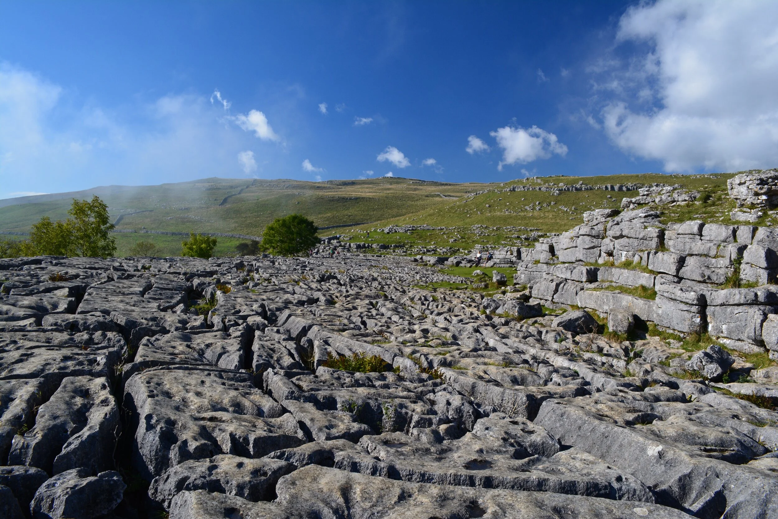
The limestone landscape of the southern and western Dales has two more distinctive features. First is the ‘karst’ landscape which is particular to limestone areas. Limestone dissolves in water containing carbon dioxide (which can occur as a form of acid rain) which produces a network of underground channels. This diverts streams underground and creates a complex hidden world of passages and caves (Ingleborough Cave, Stump Cross Caverns and White Scar Caves all being great examples which can be visited without caving experience). For example, once the outflow from Malham Tarn hits the permeable limestone, it disappears underground for more than 4km, before reappearing way past Malham Cove at Aire Head.
The second is the limestone pavements that have been formed by the joint corrosive powers of glaciation and water carrying carbon dioxide – slight weakness along the rock joints have been exploited and widened to create a ‘clint’ (the main limestone block) and ‘grike’ (the crevice), the most famous of which can be seen at the top of Malham Cove but there are many other good examples around the Dales.

The remains of the lead mining industry around Blackethwaite Mill have a stunning setting in Gunnerside Gill and can be included in several stunning walks in the area, as well as on our ‘Remote Swaledale and Arkengarthdale’ walking holiday.
The impact of the mining industry
Finally, we wanted to mention mining in the Dales – whilst we always want the landscape to look as ‘natural’ as possible, and the thriving mining industry that existed in the Dales in the 1700s and 1800s has left scars on the landscape that will take centuries to heal, there’s no denying that the remnants of the mining industry found throughout the Dales do add to its character and, in some places, the old mining ruins can be fascinating to visit in their own right.
Where there are vertical fractures in sedimentary rocks (so called ‘veins’), minerals can be deposited and it is these mineral deposits that were exploited by miners. Lead has typically dominated the mining in the Dales, with rich veins mined to the north of Swaledale and on Grassington Moor. The mining remains around Gunnerside Gill, near Surrender Bridge and in Arkengarthdale are particularly interesting to visit, because of the scale of the ruins, the stunning settings and because they can be incorporated into some really fine walks!
We hope you have enjoyed this introduction to some of the main geological features that you will see around the Dales – please get in touch if you would like any information on how to fit them into a walk or if you would like to really explore the area on one of our self-guided walking holidays!